
Open User Map
Open User Map is a no-code WordPress plugin that lets visitors add and edit locations on an interactive map with approval workflows and powerful.
Visit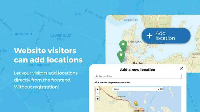
About Open User Map
Open User Map is a powerful and intuitive interactive maps plugin designed specifically for WordPress. It enables website owners to create dynamic, community-driven maps where visitors can contribute locations, routes, and areas directly from the frontend. The core value proposition of Open User Map is its simplicity: it requires no coding knowledge, no Google Maps API key, and no complex setup procedures. This makes it accessible to a wide range of users, from small business owners and nonprofit organizations to large community portals and tourism websites.
The plugin addresses a fundamental need for user-generated geographic content. Instead of relying on a single administrator to populate a map, Open User Map empowers the entire visitor base to add and update information. This crowdsourced approach ensures that the map remains current, detailed, and relevant. All submissions are managed through a built-in approval workflow, giving site owners full control over what appears on the public map. This balance between openness and moderation is key to maintaining data quality and preventing spam.
Open User Map is for anyone who needs a collaborative map. Common users include real estate agents showcasing properties, event organizers mapping festival grounds, tourism boards highlighting local attractions, community groups plotting neighborhood resources, and businesses creating store locators. The plugin transforms a static map into a living, evolving resource that grows with user input. With over 15,000 active installations and a perfect 5-star rating, it is recognized as the number two map plugin on WordPress.org, a testament to its reliability and user satisfaction. The plugin offers both a free version for core functionality and a PRO version that unlocks advanced features like custom images as maps, advanced filter interfaces, upvotes, star ratings, and opening hours. Open User Map is the straightforward, no-code solution for building interactive, user-contributed maps.
Features of Open User Map
Frontend Location Submission and Editing
Enable your website visitors to add and edit locations directly on your map from the frontend. With a simple click on the 'Add location' button, users can place a marker, fill in details, and submit their entry. All submissions are held in a queue for your approval before they become publicly visible. Furthermore, the editing capability allows users to return and update their existing locations, ensuring the map always reflects the most current and accurate information without requiring administrative intervention for every change.
Marker Categories and Filtering
Organize your map effectively by grouping locations into distinct marker categories, each with its own unique icon. This visual categorization clarifies the map's layout and allows visitors to filter through different types of locations, such as restaurants, parks, or historical sites. For added flexibility, each location can belong to multiple categories. This ensures that all relevant attributes are represented, and users can easily find exactly what they are looking for by selecting or deselecting categories from a filter interface.
Lines, Areas, and Polygons
Go beyond simple point markers by adding routes, paths, zones, and regions directly to your map. The Lines and Areas feature lets you highlight trails, service areas, event grounds, neighborhoods, construction zones, or any custom shape that helps visitors understand your map at a glance. Distances and area sizes are calculated automatically, so routes and polygons can include helpful measurements right out of the box. This feature is ideal for mapping hiking trails, delivery zones, or event boundaries.
Custom Image as Map
Upload any image and transform it into a fully interactive map with the Custom Image as Map feature. This works for overlays, floor plans, event layouts, game maps, product diagrams, campus guides, or seating charts. Users can place markers directly on top of the image with the same powerful functionality as a traditional geographic map. You can add locations, display custom fields, enable filtering, and create an engaging, clickable experience tailored exactly to your specific use case, all without needing a geographic background.
Use Cases of Open User Map
Community Resource and Amenity Mapping
A local community group or neighborhood association can use Open User Map to create a comprehensive map of local resources. Residents can submit locations of community gardens, public art installations, free Wi-Fi hotspots, playgrounds, and emergency shelters. The approval workflow ensures that only verified and appropriate resources are displayed. This creates a valuable, self-sustaining resource that grows with the community's input, helping new residents and visitors discover what the area has to offer.
Tourism and Travel Guide Maps
Tourism boards and travel bloggers can build interactive maps that allow visitors to contribute their own favorite spots. Users can add hidden gem restaurants, scenic viewpoints, unique shops, and off-the-beaten-path attractions. The categories and filtering features allow tourists to filter by activity type, such as hiking, dining, or shopping. The upvoting and star rating features then help highlight the most popular and highly recommended locations, creating a dynamic and trustworthy travel guide driven by real visitor experiences.
Event and Festival Grounds Mapping
Event organizers can use Open User Map to map out festival grounds, conference venues, or large-scale events. The Lines and Areas feature is perfect for marking stages, camping zones, parking areas, and food vendor locations. Attendees can then use the map to navigate the event. Organizers can also allow vendors to submit their own booth locations or for attendees to mark meeting points. The custom image as map feature can overlay a festival map onto a real or stylized background for a branded experience.
Real Estate and Property Locator
Real estate agents and property management companies can create a map of available properties for sale or rent. Agents can add properties with detailed custom fields for price, number of bedrooms, square footage, and property type. Potential buyers or renters can filter properties by these custom fields to find exactly what they need. The frontend submission feature can also allow property owners to submit their own listings for review, streamlining the process of populating the map with current inventory.
Frequently Asked Questions
Do I need a Google Maps API key to use Open User Map?
No, you do not need a Google Maps API key. Open User Map is designed to work without any external API keys or complex setup. This eliminates the common headache of managing API keys, billing accounts, and usage quotas associated with other map solutions. You can install the plugin and have a fully functional interactive map running on your WordPress site within minutes.
How does the approval workflow for user submissions work?
When a website visitor submits a new location or edit, it is not immediately published on the public map. Instead, the submission is placed into a moderation queue within your WordPress admin dashboard. You can review each submission, including the marker placement, title, description, and any custom fields. You then have the option to approve, edit, or delete the submission. This gives you full control over the content on your map, ensuring accuracy and preventing spam.
Can I customize the appearance and fields of the map markers?
Yes, Open User Map offers extensive customization options. You can create custom fields for your locations, including text boxes, links, checkboxes, and dropdown menus. This allows you to gather exactly the information you need from users, such as phone numbers, website URLs, or operating hours. You can also customize marker icons by grouping them into categories, each with a unique icon, and you can style the map to match your website's branding.
Is there a free version of Open User Map, and what does it include?
Yes, there is a free version of Open User Map available for download on WordPress.org. The free version includes core features such as frontend location submission and editing, marker categories and filtering, and a basic approval workflow. It is a fully functional plugin perfect for many standard mapping needs. The PRO version, available for a fee, unlocks advanced features like Custom Image as Map, Advanced Filter Interface, Upvotes, Star Ratings, Opening Hours, and Regions. You can try the PRO version free for 7 days with no credit card required.
Similar to Open User Map

Unifyca is a centralized platform for agency WordPress site management, audit, and backup.

A categorized collection of premium React and Tailwind CSS UI examples and blocks for building modern web apps.

Webleadr instantly finds and contacts local businesses without websites to generate web design leads for you.

SiteMD instantly scans your website for SEO, speed, security, and broken link issues, delivering a plain-English health report.

Idearium creates impactful websites and marketing strategies that drive growth and enhance online visibility for your.

Easily host and share any file with a simple drag and drop, getting a live URL in seconds.

Crawlkit provides a simple API to extract structured data and screenshots from any website with just one request.

Compare SaaS boilerplates by features and tech stacks to launch your app faster.